Application Description
This GPS Map Camera app merges camera functions with GPS location tracking. Its geotagging, GPS scanning, and mapping features let users visually document their journeys, viewing photos on an integrated GPS map. The app also adds GPS data to existing photos, creating a location-based photo album. Its intuitive design works flawlessly with GPS-enabled devices, making it ideal for both casual and professional photographers needing geolocation tagging.
The GPS Map Camera App boasts six key benefits:
-
Integrated Camera and GPS: Capture photos while simultaneously recording precise geolocation data, creating a visual travelogue.
-
Versatile Photo Capture and Tracking: Use the built-in GPS camera or add GPS location data to existing images.
-
Comprehensive Mapping: Easily visualize photos on a GPS map, showing their location relative to your route.
-
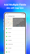
Customizable Date/Time Stamps: Add date and time stamps to photos in your preferred format.
-
Personalized Photo Management: Save photos with custom names and utilize live navigation for streamlined organization.
-
Lightweight Alternative: A Lite version provides many core features with a smaller device footprint.
Screenshot


Reviews
Post Comments
Latest Articles

Mobirix Launches Cute Cat Merge Game: Merge Cat Town
- Merge Cat Town: Mobirix's charming new puzzle game brings feline fun- Combine items to restore and upgrade your cuddly cats' island paradise- Expand your village by welcoming new feline friends and structuresThe match-merge genre has seen countless

Stickman RPG Opens Pre-registration
Hero Stickman is now available for pre-registration on Google Play, and it's anything but your typical RPG. Featured in Google Play's Pre-Registration section, this game promises an experience worth your attention.You'll lead a team of Stickman Warri

Pokémon TCG Pocket Launches Ultra Beast Event
The latest Pokémon TCG Pocket Mass Outbreak event has begunThe Ultra Beasts return to center stageComplete challenges or use Wonder Pick to fill collection gaps or obtain new cardsPokémon TCG Pocket players were thrilled by the recent Extradimensiona
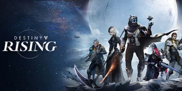
Destiny: Rising Available For Pre-Download Before Launch
Pre-downloads are now available globally, with over 10 million players already pre-registeredEarly access rewards include 200 free draws, exotic weapons, and special Destiny 2 crossover emblemsMobile version features Raids, Strikes, roguelike modes,

PUBG Mobile kicks off Friend Fest event and busts a Guinness World Record in the process
Fortnite has achieved a Guinness World Record, but not for what you might expectThis is part of the hybrid Friend Fest event happening until February 16thJoin Fortnite now to take part, or look for events near youFortnite, the mobile version of the p
Lego's $1,000 Star Wars Death Star Emerges in Leak
Leaked images seem to confirm a massive new LEGO Death Star set, rumored to contain 9,023 pieces, cost $1,000, and release this October.Instead of presenting the full spherical battle station, this version offers a cross-section view to highlight the
Apps like GPS Map Camera App


Vintage Camera - Dazz
Photography丨33.00M


Latest Apps

フロラクロマ ヘアサロン
Beauty丨61.6 MB

salone CARO(カーロ)
Beauty丨61.9 MB

Maria Beleza
Beauty丨9.0 MB
![熊本のHairSalon YELLOW[ヘアサロンイエロー]](https://images.dshu.net/uploads/78/173155007867355b7e469e0.webp)
熊本のHairSalon YELLOW[ヘアサロンイエロー]
Beauty丨64.7 MB

福岡市中央区天神の美容室【BIRTH】ーバースー 公式アプリ
Beauty丨28.3 MB

Eyelash Salon Kaiの公式アプリ
Beauty丨7.4 MB

Cuma Mesajları
Personalization丨38.50M

Trending Apps
MORE +


Top News
MORE +


01
01-16
Zenless Zone Zero Confirms Version 1.5 Special Program Livestream Date and Time
SummaryZenless Zone Zero revealed the start date for Version 1.5 "Astra-nomical Moment" on January 10 at 19:30 (UTC+8).Version 1.5 plans to add S-Rank characters Astra Yao and Evelyn Chevalier.Not much else is known about Version 1.5, though recent leaks have teased plenty of new content and events
02
01-21
Final Fantasy Updates Fix Controller Glitch
Patches for Final Fantasy VII Remake are now available on Steam, the Epic Games Store, and PlayStation 5. This update resolves issues with controller vibration motors. The game follows Cloud Strife, a former SOLDIER, as he joins Avalanche to prevent Shinra Electric Power Company from destroying th
03
04-18
"Jurassic World Rebirth Trailer Unveils Dinosaur Chaos Before Summer Release"
Jurassic World Rebirth made a roaring entrance during Super Bowl Sunday with a special trailer that showcased even more dinosaur action in anticipation of its July 2025 premiere. The latest footage features stars Scarlett Johansson and Mahershala Ali, who initially capture the audience's attention b
04
12-12
Immersive Adventure Awaits in 'In the Turquoise Moonglow' Update for Wuthering Waves
Wuthering Waves Version 1.2 Update: A Sneak Peek at "In the Turquoise Moonglow"
Get ready, Wuthering Waves players! Kuro Games is launching Phase One of the highly anticipated Version 1.2 update on August 15th. A new trailer reveals exciting additions, including a fresh Resonator, new weapons, ques
05
04-24
"Dune: Awakening Delay Extended by Three Weeks for Beta-Inspired Changes"
Dune: Awakening, the highly anticipated open-world survival MMO inspired by Frank Herbert's iconic sci-fi novels and Denis Villeneuve's films, has been pushed back to a new release date of June 10, 2025. Funcom, the game's developer, announced this delay alongside an exciting early access opportunit
Topics
More +